

Thorverton History Society members hear of the boundaries and fords around the area
“WOLVES, Ways and Watercourses - Exploring the Anglo-Saxon Boundaries of the Cridie, 739CE" was the title of the Zoom talk presented to Thorverton History Society by Tony Gale on Friday, November 26.
We were treated to an exploration of our wider local area by this excellent speaker who has developed his interests of boundaries and fords around the Exe Valley coinciding with interests expressed by Jenny Bennet about the former ford crossing of the Exe at Fortescue.
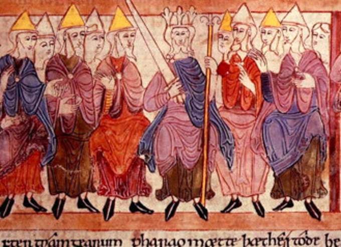
Tony gave us an entertaining and informative presentation examining the evidence and physical manifestation of the boundaries of an Anglo Saxon grant of land made by King Aethelheard to the Bishop of Sherbourne within which to build a minster at Cridie.

Named as the “Great Crediton Charter” (739BCE) sadly the original no longer exists, however, a copy is held in the Bodleian library in Oxford and allows us a fascinating insight as to boundary definition at a time of changing land ownership from the Dummonians to the West Saxons. The document itself, describes a well defined broad area which today would be bounded by Crediton-Brampford-Exwick-Newton St Cyres-Hittisleigh-Drewsteignton-Spreyton-Clannaborough-Morchard Bishop-Kennerleigh-Sandford and back to Crediton.
The Old English language immerses us in the concept of the land as “home”, where streams, rivers, fords, hills and valleys define the Saxon view.
There is no specific mention of settlements or farms which become prevalent in Norman documents, and the importance of some man made features only appear in as much as they are dictated by the landscape… such as major routes, “herepaths” (or highways) guided by the topographical features and forts or geographically defensible sites. In addition, and as we ourselves have appreciated more during lockdown, nature impacts on our perception of the landscape and often defines our sense of place, so these appear as part of the naming process in the Old English of the Charter through the presence of eagles, hawks, foxes and deer.
Previous studies by A S. Napier, H. P. R. Finberg “Some Crediton Documents” and D. Hooke provided quality research, data and evidence to enable Tony to don his walking boots and explore the boundary, unearth the reasons and identify some of the present day evidence for the 77 identifiable boundary points over 60 miles of delineated area by detailed ground work and then relating this to the text of historical document.
Some features like “No Mans chapel” no longer exist in situ having been re-located and re-built in Crediton Cemetery, but the Three Limbed Oak and evidence for the Fortescue crossing of the Exe remain, which provoked an interesting discussion returning to our previous TDHS talk by Bill Harvey concerning the bridges and crossings of the Exe.
The likelihood of any bridges in the Saxon era being made of wood and thus transient as well as superseded by later highways and stone structures, as well as the changing course of the Exe itself, has meant that this bounded area gives us a fascinating hint at the evolution of our landscape.
As noted by W. G. Hoskins “One cannot understand the English landscape and enjoy it to the full, apprehend all its wonderful variety from region to region (often within the space of a few miles), without going back to the history that lies behind it”.
This was a lovely talk for those with knowledge of the area, supported by photographs and historical documents giving the audience an opportunity to appreciate the layers of landscape that still exists for us to find.
Our meeting in January is our AGM and we hope will be a face-to-face event in the WI hut and we look forward to welcoming new and existing members as well as our new committee member, Andy Brewer.
In February, we welcome Derek Gore to talk to us on the subject of Vikings in the West Country.
Recorded by Ann Marshall
Comments
This article has no comments yet. Be the first to leave a comment.